

100-150 Ton Lowboy Trailer Route Survey: Bridge, Gradient and Turning Checks Before Dispatch

A heavy machine can be loaded correctly, secured correctly, and still have no workable path to the destination. The problem may appear beneath a bridge, at a railway crossing, on a sharp crest, or during the final turn into a project site. A 100-150 ton lowboy trailer route survey needs to test the complete loaded combination against the real route before dispatch. The useful question is not whether the road looks suitable on a map. It is whether the planned tractor, trailer, cargo position, axle arrangement, permits, and road geometry can complete the movement without an unresolved structural, clearance, turning, or access problem.
Why High-Capacity Moves Require a Route-Specific Survey
A navigation route answers where a road goes. Heavy-haul planning has to answer whether one specific loaded combination can actually use it. That difference becomes important as soon as bridges, narrow intersections, steep transitions, overhead structures, or restricted pavement enter the route.
For example, a highway may provide generous width and a direct line between two industrial areas. However, one bridge can introduce an unresolved loading condition. An alternative road may avoid that structure but add a tight village turn and a sharp railway crossing. Distance alone therefore says little about real route feasibility.
The trailer also does not follow the tractor as a single rigid shape. During a turn, the tractor front, gooseneck, trailer axle group, rear structure, and cargo overhang all travel through different arcs. Consequently, a junction that accepts ordinary articulated traffic may still create an inside tracking or rear-swing conflict.
Vertical geometry creates another set of constraints. A lower deck can help reduce loaded height beneath overhead structures. At the same time, low structural points can become more sensitive to crests, drainage dips, railway crossings, bridge approaches, and raised site entrances.
For that reason, a heavy-haul lowbed trailer needs to be considered together with the tractor, cargo, axle arrangement, and route profile. Trailer capacity alone cannot confirm whether the journey works.
A route-specific survey also separates observations from evidence. Satellite imagery may identify a bridge or narrow junction. Nevertheless, imagery does not establish bridge capacity, current clearance, pavement support, or permit approval.
Accordingly, each critical point should finish with a clear status. A location may be suitable, suitable after a defined action, unresolved pending technical verification, or unsuitable for the planned configuration. That status is what turns route information into a dispatch decision.
A route that 鈥減robably works鈥� still contains an open decision
A familiar road, an older survey, or a previous heavy move can help with early screening. However, none of them automatically confirms the bridge loading, turning envelope, breakover clearance, or legal conditions of a different loaded combination.
Confirm the Loaded Combination Dimensions and Mass
Route work should begin with the combination expected to leave the yard. An empty trailer drawing is not enough. The tractor, trailer, cargo position, support arrangement, axle layout, and transport orientation all influence the envelope that reaches the road.
Consider a tracked machine prepared for a long-distance move. A published machine height may look comfortably below an overhead restriction. However, transport blocks, guards, a revised boom position, temporary frames, or another support arrangement can change the final loaded height.
Measure the shape that will actually travel
Loaded height is only one part of the route envelope. Width affects lane position and bridge clearance, while length affects turning space and intersection occupation. Cargo extending beyond the trailer can also create front or rear sweep outside the trailer frame.
Ground clearance deserves a defined reference point as well. Depending on the final setup, the limiting point may sit beneath the deck, gooseneck, suspension area, rear frame, ramp structure, or cargo. Therefore, an unloaded clearance figure may not describe the actual move.
Gross mass is not the complete bridge-loading picture
Total combination mass provides an essential project value. Even so, bridge assessment may also depend on tractor axle reactions, trailer axle-group reactions, axle spacing, and the travel position across the structure.
Cargo position can change those reactions. Moving equipment forward may reduce rear overhang while shifting more reaction toward the tractor. Moving it rearward can produce a different distribution. Consequently, the loading position used during route and structural review should match the dispatch position.
The same issue appears when equipment orientation changes. Turning a machine around on the deck may improve one clearance problem but create another load-distribution or overhang condition. A route approval based on the first configuration should not simply follow the second.
The useful starting data is practical, not complicated
- Tractor configuration and relevant operating dimensions
- Trailer configuration and axle arrangement
- Overall loaded length, width, and height
- Front and rear cargo overhang
- Relevant low ground-clearance points
- Cargo position and support arrangement
- Gross combination mass
- Available tractor and trailer axle-reaction information
- Attachments or temporary transport fixtures that change the envelope
If those values remain provisional, route approval should remain provisional as well. A later tractor substitution, cargo repositioning, or axle-layout change can affect earlier bridge, turning, and breakover conclusions.
Lowboy Configuration References
Route Planning Starts After the Transport Configuration Is Defined
These two BOCA products are relevant references for high-capacity lowboy work. They are shown here because route geometry depends on the actual trailer arrangement. The images do not imply that either configuration is automatically suitable for a particular bridge, road, or jurisdiction.
Capacity labels do not define the route envelope
A 100-ton and a 150-ton configuration may differ in axle count, axle spacing, axle-group length, loaded length, steering behaviour, and tractor requirements. Adding axles may help distribute load, but a longer axle group can also increase off-tracking, intersection occupation, and the number of wheel paths that must remain on supported pavement. Compare the proposed dispatch geometry and verified axle reactions rather than assuming that the nominal capacity label determines bridge or route suitability.
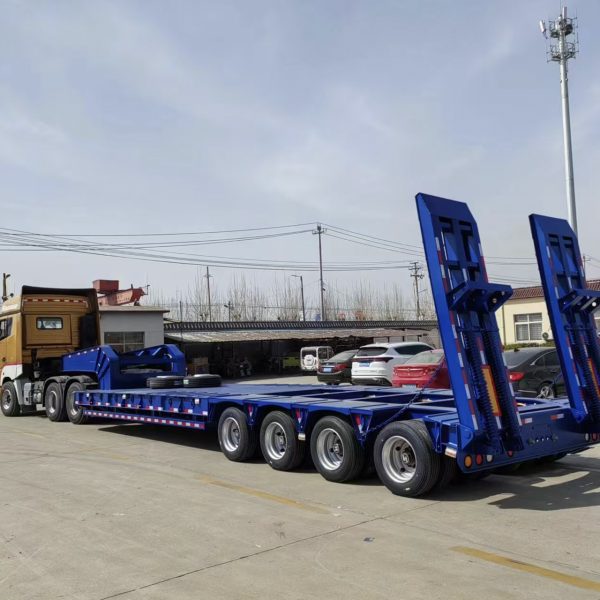
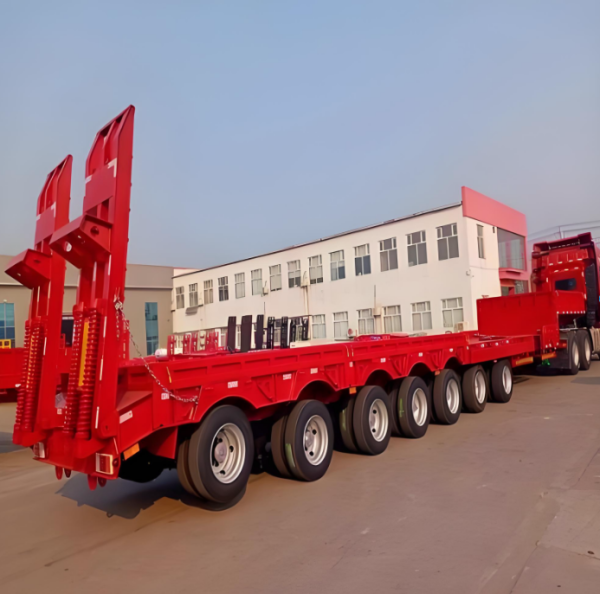
Final route feasibility should follow the real dispatch configuration, measured cargo envelope, axle information, destination regulations, and infrastructure verification rather than a product photograph or nominal capacity label.
Check Bridges, Structures and Pavement Restrictions
A bridge creates at least two separate questions. First, does the complete loaded profile physically fit through or across the structure? Second, can the structure accept the planned load under the applicable authority process? Passing one check does not answer the other.
Clearance has to follow the real lane position
A bridge clearance check should consider where the combination will actually travel. Arched structures, road camber, resurfacing, barrier position, and a wide cargo envelope can all change the usable vertical space across a roadway.
The same logic applies to tunnels, overhead gantries, pipe bridges, utility lines, pedestrian structures, temporary scaffolding, and construction equipment. Moreover, an older street image cannot confirm whether a temporary obstruction still exists.
A common field situation illustrates the problem. The highest cargo point appears lower than a bridge clearance marker when viewed from the roadside. However, the wide load needs a different lateral position, and the road rises slightly beneath one side of the structure. The apparent margin can therefore become much smaller on the real travel line.
When clearance becomes close enough to influence the route decision, visual estimation should stop. Suitable field measurement or reliable authority information should confirm the available space. Any required clearance margin should follow applicable local regulations and project procedures.
Road class does not establish bridge capacity
A road may carry heavy commercial traffic every day and still contain a bridge requiring abnormal-load review. Structural response can depend on axle reactions, axle spacing, total mass, travel position, span arrangement, and current bridge condition.
Therefore, frequent heavy traffic is not evidence that a specific movement has structural approval. Likewise, the absence of a visible roadside restriction should not be treated as automatic clearance.
Where capacity cannot be confirmed, the structure should remain unresolved. Depending on the jurisdiction, the next step may involve the road authority, bridge owner, or a qualified structural engineer.
The road edge can become part of the load path
Bridge structures are not the only support concern. A tight turn may push trailer wheels toward the pavement edge, shoulder, drainage channel, utility cut, or temporary surface. Those areas may not provide the same support as the normal wheel track.
Consequently, swept-path clearance should be compared with surface condition as well as geometric space. A wide-looking junction can still fail if the inside wheel path crosses an unsupported verge or weak drainage structure.
Measure Grades, Crests, Dips and Breakover Points
A long uphill grade is easy to notice during a route visit. However, a short transition at a railway crossing or site entrance can create the more immediate clearance problem. Gradient review therefore needs to consider both sustained slope and the change in slope between adjoining surfaces.
Consider an industrial entrance beside a public road. The road falls toward a drainage channel, while the entrance rises immediately after the channel. The distance may be short, yet the tractor and trailer can occupy several different angles during the maneuver.
A low deck changes what becomes the limiting point
At a crest, the tractor may begin descending while the trailer remains on the rising approach. As articulation changes, a low deck member, rear structure, or cargo component can move closer to the pavement.
A dip creates the reverse geometry. The tractor may already be climbing while part of the trailer remains on the lower surface. Therefore, railway crossings, drainage dips, bridge approaches, raised entrances, and abrupt temporary ramps deserve more than a simple gradient estimate.
Crossing a sloped entrance diagonally can make the situation more complex. Wheels on opposite sides may sit at different elevations. Consequently, a simple two-dimensional side profile may not represent the lowest clearance during the maneuver.
Gradient is also an operating condition
Long grades affect traction, braking, speed control, and available stopping space. Nevertheless, a useful route survey should not invent one universal acceptable gradient. Performance depends on the tractor, combination mass, surface condition, weather, and applicable operating rules.
Instead, the survey should identify sections that require deeper review. A loose uphill quarry road, for example, creates different traction conditions from dry pavement. A long descent can also require a defined operating approach before dispatch.
Stopping and staging space matters as well. If a difficult climb begins immediately after a congested junction, there may be little room to establish alignment or controlled speed. Therefore, the approach to the grade can be as important as the slope itself.
Record why the location matters
鈥淪teep hill鈥� gives little decision value. 鈥淭raction and braking review required for the loaded combination鈥� creates a next step. Likewise, 鈥渟harp crest鈥� becomes useful when the record identifies the low clearance point and the measurement still required.
Review Turning Space, Lane Width and Roadside Obstacles
A difficult heavy-haul turn often looks harmless before the combination arrives. The tractor can enter the intersection cleanly, while the trailer axle group cuts toward the inside curb and the rear structure moves toward the opposite side.
That off-tracking means lowboy turning clearance cannot be judged from the tractor path alone. The full movement envelope should include tractor sweep, trailer inside tracking, axle-group path, cargo overhang, and rear swing.
Small obstacles often decide a large movement
Large roads can still contain small but decisive restrictions. Traffic islands, signal poles, signposts, guardrails, utility cabinets, trees, walls, drainage ditches, and gate posts frequently occupy the exact space needed during a wide maneuver.
A site gate can create a similar surprise. The opening may provide enough static width. However, the approach road may not allow the tractor to straighten before entry. The trailer then reaches the gate at an angle and uses much more lateral space than the gate measurement suggests.
The route should also look beyond the gate. A successful entrance provides little value if the combination immediately meets a parked crane, container stack, material stockpile, temporary office, or second tight turn.
Field geometry and swept-path analysis should support each other
For constrained intersections, swept-path analysis can provide useful evidence. However, a generic semitrailer template may give the wrong answer. Tractor wheelbase, kingpin position, axle spacing, steering behavior, overall length, and cargo overhang should reflect the planned configuration.
Simulation also needs current site geometry. Satellite imagery can predate a new median, barrier, gate, building, or road reconstruction. Therefore, difficult turns are stronger when a model is checked against recent field measurements and photographs.
Photographs should capture context rather than only the obstacle. An approach view explains tractor positioning. An apex view shows the inside conflict. Meanwhile, an exit view reveals rear swing and alignment after the turn.
A turn also needs enough space to manage the maneuver
Some turns require temporary use of opposing lanes or a controlled traffic hold. Others need a removable obstruction cleared before arrival. Accordingly, geometric feasibility and traffic-control feasibility should be reviewed together.
A maneuver that works only when every temporary condition is perfect should remain conditional until those actions are confirmed. A parked vehicle scheduled for removal is still an obstacle until the route team has evidence that the space is clear.
For projects where trailer geometry is still being defined, the BOCA 100鈥�150 ton lowboy trailer configurations provide relevant equipment references. The final swept path still needs the exact dispatch geometry rather than a category-level assumption.
Useful Field Evidence
A photograph should explain the route, not just prove that someone visited it
A close image of a pole or curb can hide the geometry that makes it important. Therefore, critical locations are easier to review when the record includes both the obstacle and the approach.
- Approach direction and intended lane position
- The bridge, curb, pole, gate, crest, or road edge creating the restriction
- The exit path after the critical location
- A measurement reference where dimensions affect the decision
- Date and clear route-location reference
Plan Permits, Escorts and Local Engineering Verification
Physical passage does not equal legal permission. Oversize and overweight requirements vary by country, region, municipality, port, and private-road authority. Therefore, permit work should develop alongside the technical route survey rather than after the route appears finished.
Permit authorities may require overall dimensions, axle spacing, axle reactions, cargo information, route details, and movement dates. Consequently, the submitted configuration should match the combination eventually released for transport.
If the tractor changes, cargo moves on the deck, or the axle arrangement changes, affected approvals may need review. A configuration change should therefore reach permitting and engineering personnel before dispatch rather than remain an operational detail.
Escort planning should connect to specific route actions
An escort requirement becomes more useful when the route record explains where control is needed. One junction may require opposing traffic held during a turn. Another section may require clearance observation before the combination moves beneath an overhead restriction.
However, escort procedures must follow the applicable local rules. The same applies to police involvement, railway crossings, utility coordination, port access, and temporary occupation of public roads.
Structural uncertainty should stop assumptions
When bridge capacity cannot be established from reliable authority information, the correct next step is technical verification. Depending on local requirements, a qualified engineer may need axle reactions, axle spacing, structure information, and the planned travel position.
Temporary site works can require the same discipline. Culverts, temporary bridges, prepared ramps, reinforced access roads, and modified entrances should not be treated as suitable merely because heavy equipment has crossed them before.
Overhead utility conflicts also need specialist coordination. Power and communication lines should not be treated as obstacles that can simply be lifted or moved. Local utility requirements and qualified personnel should control the assessment.
Where the transport configuration remains under discussion, the available lowbed configurations can provide a starting point. Route legality, structural approval, and permit conditions still remain matters for the relevant authorities and qualified local professionals.
Create a Route Record and Go/No-Go Decision List
Hundreds of photographs do not automatically create a usable route record. The document has value when each critical point shows what was checked, what evidence supports the conclusion, what remains open, and what would stop the movement.
The record should begin with the loaded combination and revision status. After that, critical locations are easier to understand in travel order. A port gate, urban turn, bridge, grade, railway crossing, and final site entrance should appear in the sequence the movement will encounter them.
Pass
Available evidence supports the planned movement under the recorded configuration and route conditions.
Conditional
The location can proceed only after a defined approval, field action, obstruction removal, traffic-control measure, or final verification.
Unresolved
Important evidence is still missing. An unverified bridge capacity or uncertain overhead clearance belongs here rather than under an assumed pass.
No-Go
The planned configuration cannot use the location under the current conditions. Another route, configuration, or approved modification is required.
For each critical point, record the location and travel direction, loaded-configuration revision, measured or reported restriction, evidence source, required action, responsible party, target date, and final status. This keeps an unresolved observation from being mistaken for an approved route condition.
Open actions need ownership
A note saying 鈥渃lear parked equipment鈥� is not a completed route action. The record needs responsibility and evidence that the space will actually be available before arrival. Likewise, 鈥渂ridge review required鈥� remains unresolved until the required approval exists.
Version control matters for the same reason. Heavy-haul planning can involve transport operations, permitting personnel, site teams, escorts, and engineers. Everyone should therefore work from the same current route revision.
The final site entrance can change faster than the public road
Construction and industrial sites rarely stay static. Material stockpiles move, temporary fencing appears, trenches open, cranes change position, and unsealed surfaces deteriorate after weather. Consequently, an entrance photographed weeks earlier may no longer represent the arrival condition.
A final site check should confirm the gate, internal turning area, staging position, and relevant unloading approach. If the geometry changes materially, the affected section needs another decision before departure.
Run one final configuration check before release
The latest route record should be compared with the actual combination prepared for dispatch. A different tractor, altered cargo position, additional support material, or substituted trailer can affect previous conclusions.
Current road conditions should also be reviewed. New roadworks, closures, incidents, storm damage, or temporary events can make part of the approved path unavailable.
Standard navigation systems should not override an approved abnormal-load route. A short detour that looks efficient may introduce an unassessed bridge, narrow turn, or vertical transition.
FAQ
A route becomes dispatchable when the open questions are closed
The strongest route record is not necessarily the longest one. Instead, it explains where the combination can pass, where conditions still apply, and where further verification remains necessary.
Before release, three actions provide a practical final filter:
- Match the actual tractor, trailer, cargo position, dimensions, and axle information to the latest route record.
- Close every structural, clearance, grade, turning, permit, and site-access condition with suitable evidence.
- Stop the release process when a material configuration or route condition changes, then reassess the affected location.
Route and Trailer Configuration Review
Bring the Actual Route Data Into the Trailer Discussion
A useful project package includes equipment details, transport dimensions, operating mass, cargo position, tractor and trailer arrangement, origin and destination, and photographs of critical bridges, grades, turns, and site entrances.
Where available, bridge information, axle-reaction data, route measurements, permit conditions, road-authority comments, and destination-country requirements should also be included. Those details make it possible to discuss trailer configuration around the real transport task rather than a nominal capacity label.
Most importantly, a 100-150 ton lowboy trailer route survey should remain a route-feasibility decision. Structural approval, legal axle loading, permits, traffic control, and infrastructure verification must continue to follow applicable local regulations and qualified professional review.
Request a Trailer Configuration Review